Département Loir-et-Cher
| Loir-et-Cher | |
|---|---|
 |   |
Region | Centre-Val de Loire |
Präfektur | Blois |
Unterpräfektur(en) | Romorantin-Lanthenay Vendôme |
Einwohner | 333.050 (1. Jan. 2015) |
Bevölkerungsdichte | 53 Einw. pro km² |
Fläche | 6.343,44 km² |
Arrondissements | 3 |
Gemeindeverbände | 12 |
Kantone | 15 |
Gemeinden | 272 |
Präsident des Départementrats | Maurice Leroy[1] (UDI) |
ISO-3166-2-Code | FR-41 |
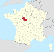
 Lage des Départements Loir-et-Cher in der Region Centre-Val de Loire | |
Das Département Loir-et-Cher [.mw-parser-output .IPA a{text-decoration:none}lwaʀeˈʃɛːʀ] ist das französische Département mit der Ordnungsnummer 41. Es liegt in der Mitte des Landes in der Region Centre-Val de Loire und ist nach den Flüssen Cher und Loir benannt.
Inhaltsverzeichnis
1 Geographie
2 Geschichte
3 Städte
4 Verwaltungsgliederung
5 Weblinks
6 Einzelnachweise
Geographie |
Das Département Loir-et-Cher grenzt im Norden an das Département Eure-et-Loir, im Nordosten an das Département Loiret, im Südosten an das Département Cher, im Süden an das Département Indre, im Südwesten an das Département Indre-et-Loire und im Nordwesten an das Département Sarthe.
Bedeutendster Fluss ist die Loire, die das Département von Nordosten nach Südwesten hin teilt und dabei den zentral gelegenen Hauptort Blois passiert. Der Loir, ein linker Nebenfluss der Sarthe, durchfließt das Département im Norden, der zweite namensgebende Fluss Cher durchfließt es im Süden.
Geschichte |
Das Département wurde am 4. März 1790 aus dem Westteil der Provinz Orléanais gebildet.
Es gehört seit 1960 der Region Centre an, die 2016 in Centre-Val de Loire umbenannt wurde.
Städte |
Die bevölkerungsreichsten Gemeinden des Départements Loir-et-Cher sind:
| Stadt | Einwohner (2015) | Arrondissement |
|---|---|---|
| Blois | 45.710 | Blois |
| Romorantin-Lanthenay | 17.748 | Romorantin-Lanthenay |
| Vendôme | 16.716 | Vendôme |
| Vineuil | 7.724 | Blois |
| Mer | 6.202 | |
| Salbris | 5.356 | Romorantin-Lanthenay |
Verwaltungsgliederung |
Das Département Loir-et-Cher gliedert sich in 3 Arrondissements, 15 Kantone und 272 Gemeinden:

Gemeinden und Arrondissemente im Département Loir-et-Cher
| Arrondissement | Kantone | Gemeinden | Einwohner 1. Januar 2015 | Fläche km² | Dichte Einw./km² | Code INSEE |
|---|---|---|---|---|---|---|
Blois | 7 | 94 | 000000000151292.0000000000151.292 | 1.974,41 | 000000000000077.000000000077 | 411 |
Romorantin-Lanthenay | 7 | 77 | 000000000111726.0000000000111.726 | 2.646,69 | 000000000000042.000000000042 | 413 |
Vendôme | 3 | 101 | 000000000070032.000000000070.032 | 1.722,34 | 000000000000041.000000000041 | 412 |
| Département Loir-et-Cher | 15 | 272 | 000000000333050.0000000000333.050 | 6.343,44 | 000000000000053.000000000053 | 41 |
Siehe auch:
- Liste der Gemeinden im Département Loir-et-Cher
- Liste der Kantone im Département Loir-et-Cher
- Liste der Gemeindeverbände im Département Loir-et-Cher
Weblinks |
Département Loir-et-Cher (französisch)
Präfektur des Départements Loir-et-Cher (französisch)
Einzelnachweise |
↑ le-loir-et-cher.fr abgerufen am 3. Mai 2015.
.mw-parser-output div.BoxenVerschmelzen{border:1px solid #AAAAAA;clear:both;font-size:95%;margin-top:1.5em;padding-top:2px}.mw-parser-output div.BoxenVerschmelzen div.NavFrame{border:none;font-size:100%;margin:0;padding-top:0}
.mw-parser-output div.NavFrame{border:1px solid #A2A9B1;clear:both;font-size:95%;margin-top:1.5em;min-height:0;padding:2px;text-align:center}.mw-parser-output div.NavPic{float:left;padding:2px}.mw-parser-output div.NavHead{background-color:#EAECF0;font-weight:bold}.mw-parser-output div.NavFrame:after{clear:both;content:"";display:block}.mw-parser-output div.NavFrame+div.NavFrame,.mw-parser-output div.NavFrame+link+div.NavFrame{margin-top:-1px}.mw-parser-output .NavToggle{float:right;font-size:x-small}

Départements in der Region Centre-Val de Loire
18 Cher | |
47.5911111111111.3402777777778Koordinaten: 47° 35′ N, 1° 20′ O


