Hrabstwo Tallahatchie
Hrabstwo Tallahatchie Tallahatchie County | ||||
| ||||
 | ||||
Państwo | ||||
Stan | ||||
| Siedziba | Charleston | |||
| Kod statystyczny | FIPS 6-4: 28135 | |||
| Powierzchnia | 1688,88[1] km² | |||
| Populacja (2009) • liczba ludności | 12 638[2] | |||
Położenie na mapie Missisipi  | ||||
33°57′01,45″N 90°10′12,00″W/33,950403 -90,170000 | ||||
Portal | ||||
Hrabstwo Tallahatchie (ang. Tallahatchie County) – hrabstwo w stanie Missisipi w Stanach Zjednoczonych. Obszar całkowity hrabstwa obejmuje powierzchnię 652,08 mil² (1688,88 km²). Według szacunków United States Census Bureau w roku 2009 miało 12 638 mieszkańców[2].
Hrabstwo powstało w 1833 roku[3].
Miejscowości |
- Charleston
Glendora (wieś)- Sumner
- Tutwiler
Webb[4]
| Populacja hrabstwa w poprzednich latach[3] | |
|---|---|
| Rok | Liczba ludności |
| 1980 | 17 020 |
| 1990 | 15 210 |
| 2000 | 14 903 |
| 2005 | 14 191 |
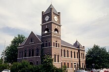
Budynek administracji hrabstwa (courthouse) w Sumner
Przypisy |
↑ US Census Bureau: Population, Housing Units, Area, and Density: 2000 (ang.). [dostęp 2012-05-22].
↑ ab US Census Bureau: Tallahatchie County (ang.). Quickfacts. [dostęp 2011-05-13].
↑ ab National Association of Counties: Tallahatchie County, MS (ang.). [dostęp 2011-05-13].
↑ National Association of Counties: Places in Tallahatchie County, MS (ang.). [dostęp 2011-05-13].
| |||||||


