篠井山
この記事の主題はウィキペディアにおける独立記事作成の目安を満たしていないおそれがあります。目安に適合することを証明するために、記事の主題についての信頼できる二次資料を求めています。なお、適合することが証明できない場合には、記事は統合されるか、リダイレクトに置き換えられるか、さもなくば削除される可能性があります。(2014年6月) |
この記事は検証可能な参考文献や出典が全く示されていないか、不十分です。 出典を追加して記事の信頼性向上にご協力ください。(2014年6月) |
| 篠井山 | |
|---|---|
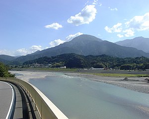 県道10号線の小鷹通付近より南方の篠井山を望む(2002年7月) | |
| 標高 | 1,394.4 m |
| 所在地 | |
| 位置 | 北緯35度14分52.2秒 東経138度25分35.4秒座標: 北緯35度14分52.2秒 東経138度25分35.4秒 |
| 山系 | 身延山地 |
 篠井山の位置
| |
篠井山(しのいさん)は、山梨県南巨摩郡南部町にある山である。標高1,394.4m。
目次
1 概要
2 関連画像
3 参考文献
4 周辺の山
概要
山名は昔、甲州の役人として赴任した従四位凡河内躬恒(おおしこうちのみつね)が登って四位山の名がついたとされる。4ヶ村の堺の山という意味かと思われる。決して高い山ではないが、麓との比高は1000mを超えているためかなり大きな立派な山に見える。堂々たる山容をしており、古来ご神体としてあがめられてきたという。登山道は南側の奥山温泉から奥に入った大洞橋からのみである。登り時間は2時間10分ほど。山頂は木々が多いが、東に富士山が望めるほか、西に枝越しに南アルプスの山々が望める。
関連画像
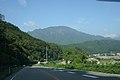
国道52号より篠井山を見上げる

篠井山から見た富士山


参考文献
- 『日本の山1000』 山と溪谷社〈溪谷カラー名鑑〉、1992年8月、360頁。.mw-parser-output cite.citation{font-style:inherit}.mw-parser-output .citation q{quotes:"""""""'""'"}.mw-parser-output .citation .cs1-lock-free a{background:url("//upload.wikimedia.org/wikipedia/commons/thumb/6/65/Lock-green.svg/9px-Lock-green.svg.png")no-repeat;background-position:right .1em center}.mw-parser-output .citation .cs1-lock-limited a,.mw-parser-output .citation .cs1-lock-registration a{background:url("//upload.wikimedia.org/wikipedia/commons/thumb/d/d6/Lock-gray-alt-2.svg/9px-Lock-gray-alt-2.svg.png")no-repeat;background-position:right .1em center}.mw-parser-output .citation .cs1-lock-subscription a{background:url("//upload.wikimedia.org/wikipedia/commons/thumb/a/aa/Lock-red-alt-2.svg/9px-Lock-red-alt-2.svg.png")no-repeat;background-position:right .1em center}.mw-parser-output .cs1-subscription,.mw-parser-output .cs1-registration{color:#555}.mw-parser-output .cs1-subscription span,.mw-parser-output .cs1-registration span{border-bottom:1px dotted;cursor:help}.mw-parser-output .cs1-ws-icon a{background:url("//upload.wikimedia.org/wikipedia/commons/thumb/4/4c/Wikisource-logo.svg/12px-Wikisource-logo.svg.png")no-repeat;background-position:right .1em center}.mw-parser-output code.cs1-code{color:inherit;background:inherit;border:inherit;padding:inherit}.mw-parser-output .cs1-hidden-error{display:none;font-size:100%}.mw-parser-output .cs1-visible-error{font-size:100%}.mw-parser-output .cs1-maint{display:none;color:#33aa33;margin-left:0.3em}.mw-parser-output .cs1-subscription,.mw-parser-output .cs1-registration,.mw-parser-output .cs1-format{font-size:95%}.mw-parser-output .cs1-kern-left,.mw-parser-output .cs1-kern-wl-left{padding-left:0.2em}.mw-parser-output .cs1-kern-right,.mw-parser-output .cs1-kern-wl-right{padding-right:0.2em}
ISBN 4635090256。 - 『山梨県の山 』 山と渓谷社〈新・分県登山ガイド〉、2006年2月。
ISBN 4635023141。
周辺の山
- 十枚山
- 大光山
- 思親山
| ||||||||||


